Tuesday, December 9, 2014


 ශ්‍රී ලංකාව (Sri Lanka)

Coastal paradises, high mountains, rolling beaches, tropical and subtropical climates.
http://www.utmthotel.com/files/hollmann/content/
header-images/sri_lanka_strand_boote-header.jpg


http://www.teatrails.com/wp-content/themes/teatrails/img/slides/
ceylon-tea-country-tea-trails-srilanka.jpg


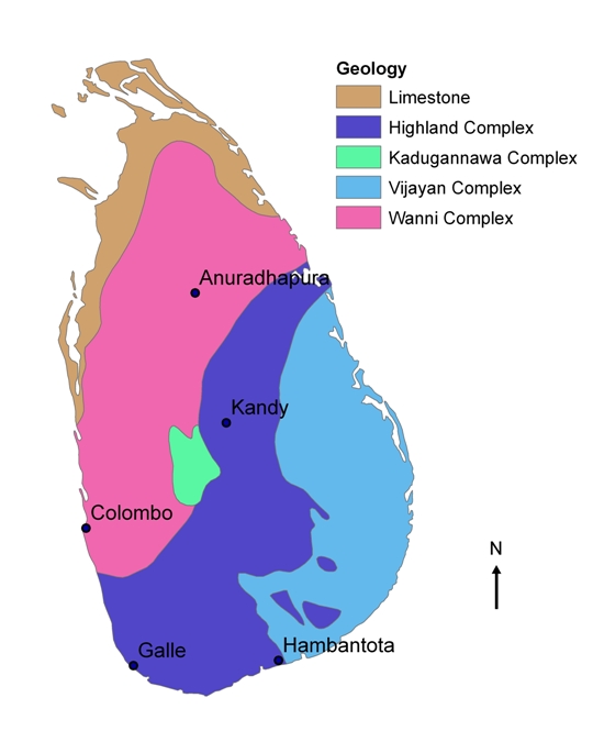
Birthed from the remnants of Gondwana, a precambrian dominant island came to form what we call Sri Lanka. Over the next 120 million years, the land mass caught a ride with the Indian plate, up past the equator, and landed as our present day Sri Lanka, located at 7° N, 81° E. with a size of 25,332 sq. miles. 


 The earth is an extremely variable, ever changing place. If not due to anthropogenic reasons like changing landscapes, biology, and chemistry, the natural rhythms of Earth will indeed change the geography of Sri Lanka drastically. Manipulations in the environment ranging from mining, damming rivers, to tectonic plate movements and local weather patterns could alter Sri Lanka indefinitely. This island is vulnerable to changing weather patterns, but it's important to think about the geologic timescale of Earth, and how the creation of this island is temporary in the form it's in now.

10,000 years from now...
http://ngm.nationalgeographic.com/2013/09/rising-seas/if-ice-melted-map


As much as I'd like to be optimistic, let's go the disaster route the future of Sri Lanka most likely is bleak and depressing. The models forecasting a rise in sea levels could have dire impacts on the coastal and lowland regions. An increase in greenhouse gasses either naturally or anthropogenicaly could increase the insolation of electromagnetic radiation, increasing the temperature of Earth, melting the ice.


http://clasfaculty.ucdenver.edu/callen/1202/Battle/Build/PlateTectonics
/srilanka_Tsunami04.jpg
The tsunami on December 24th, 2004 could be a prediction of things to come with a global climatic disturbance.


Could see increase of:
-Tsunami
-Earthquake
-Flooding and drought

Or possibly just a change in the
-Local temperature and precipitation patterns
-Monsoons
-Chemical and mechanical weathering


1,000,000 years from now...

http://www.sundaytimes.lk/100627/Plus/plus_18.html


Instead of following the coarse of the Indian plate North-East into the Eurasian plate, immense pressure building up in the fault East of Sri Lanka. The Tsunami in 2004 is evidence of this massive shift in this plate boundary that could impact life on Sri Lanka.


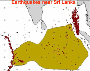
Only recently has there been a distinction in the Indian plate and the Australian plate, which were thought to be connected. New evidence is showing a possible new plate boundary in the Indian plate could be forming just 400-500km to the South of Sri Lanka.
This could mean the islands tectonic plate could begin an Eastern movement toward the Java-Sumantra subduction zone, or have major geologic events occurring in this region.


The Indian plate is moving South-East, and within several million years, could collide with the Burma plate, subducting Sri Lanka beneath it.

The island could experience a subduction process under the land mass in the Bay of Bangel, following the same Indian plate movement which formed the Himalayas.


100,000,000 years in the future...

Sri Lanka was only created 140-180 million years ago, and is only a blip in geologic materials surfacing on Earth's crust. In another 100 million years, it is highly likely that some geologic disturbance will recycle the island in some tectonic process. I would predict that a subduction zone would gobble this island, ending this island form Sri Lanka has now.

Formerly known Sri Lanka could possibly be crushed within the Eurasian plate, eaten up by another carbon and silicon based land mass, and recycled under Earth's crust into the mantel containing a stew of molten rock.


Works Cited
Dissanayake, C. B. "A New Plate Boundary near Sri Lanka: Implications for Future Geohazards." Journal of the National Science Foundation of Sri Lanka 33.1 (2010): n. pag. Web.
"Examine an Animation of Plate Movement Predicted for the Future." Examine an Animation of Plate Movement Predicted for the Future. N.p., n.d. Web. 26 Nov. 2014.
Kleinschrodt, R. "Large-scale Thrusting in the Lower Crustal Basement of Sri Lanka." Precambrian Research 66.1-4 (1994): 39-57. Web. 26 Nov. 2014.
Samarasinghe, „G B. Long-range Forecast of Climate Change: Sri Lanka Future Scenario (n.d.): n. pag. Web. 26 Nov. 2014. <http://www.ips.lk/events/workshops/19_8_09_climate_change/3_samarasinghe.pdf>.
Vitanage, P. W., 1985: Tectonics And Mineralization In Sri Lanka. TECTONICS AND MINERALIZATION IN SRI LANKA (n.d.): n. pag. Web. 26 Nov. 2014. <http://www.geologinenseura.fi/bulletin/Volume57/sgs_bt_057_pages_157_168.pdf>.

Thursday, November 13, 2014


Sri Lanka's Weather and Climate

Sri Lanka's position on the Earth lies within the tropical zone, close to the equator. Combine that with a land mass that is surrounded in water and you get a tropical paradise. The distance away from the equator or ITCZ is the first step to understanding why the temperature and precipitation in Sri Lanka is what it is today. Being 5-10 degrees way from the ITCZ, or largest incoming solar radiation point, the fluctuation of temperature is not high as you can see in the climograph below.
Sri Lankan Climograph
http://www.puttalam.climatemps.com/graph.php
Elevation plays a role in the precipitation in Sri Lanka


Annual Rainfall in Sri Lanka
http://www.meteo.gov.lk/index.php?option=com_content&view=article&id=106&Itemid=81&
Sri Lanka has four seasons, naturally fluctuating between wet and dry seasons of the different regions in Sri Lanka. 

First Intermonsoon Season is from March through April.

Southwest Monsoon season is from May to September- The Yala monsoon hits the southern and western half of the island..

Second intermonsoon season is from October to November

Northeast Moonsoon season is from December through February, while the island is getting hit by the Maha monsoons. This increases the precipitation of the Northern and Eastern parts of Sri Lanka. 

These seasons do fluxuate the temperature in Sri Lanka, but they mainly the amount of precipitation.


Seasonal Rainfall
Seasonal Rainfall
http://www.meteo.gov.lk/index.php?option=com_content&view=article&id=106&Itemid=81&


Monsoons can be influenced by the wind directions which can either be sourced from the Bay of Bangel
Sri 
Fair-Weather Clouds, Sri Lanka
http://earthobservatory.nasa.gov/IOTD/view.php?id=81833

http://eoimages.gsfc.nasa.gov/images/imagerecords/81000/81833/SriLanka_amo_2013099_lrg.jpg

Well, I just flew into the fascinating Sanibel Island, Flordia, so the physical geography of a completely new region for me is now going to be discovered. 


Works Cited
http://www.accuweather.com/en/lk/national/satellite
http://www.weather-forecast.com/maps/Sri-Lanka?over=arrows&symbols=none&type=cloud
http://www.worldtravelguide.net/sri-lanka/weather-climate-geography
http://www.meteo.gov.lk/index.php?option=com_content&view=article&id=106&Itemid=81&

Tuesday, October 14, 2014


LET'S TALK ABOUT... SOILS!
I've been trying to get a deep understanding on magnificence of all of the spheres colliding perfectly to form soil, where within one teaspoon there can contain 50 BILLION MICROBES. 
This island nation has a large spectrum of soil types that formed after many years of weathering and erosion processes. Sri Lankan soil can be broken up into hundreds of soil series that are all unique based on the site specific mineral composition, organic matter, and climate. I will take you through a few different major soil types in Sri Lanka based on the map below.
http://eusoils.jrc.ec.europa.eu/esdb_archive/eudasm/asia/images/maps/download/lk2003_so.jpg
Red-yellow podsolic soils, or newly formed soils near make up 21% of the land area. It is the "beige" and "mocha" color in the map. Podzolization occurs where seasonal variation is high, and adequate moisture is suppled to soils. The O horizon is fairly thin, with thick A horizon deeper, which is deficient in carbon and nitrogen.
http://www.ssssl.org/WZ.htm


Dry zones, or the pink regions, consist mainly of reddish brown latoslic soils or immature brown loans. These soils are found in 50% of land here. Latosiolic soils go through the process of laterization, where the soils receive high precipitation and high temperatures. As a result, it has a high content of iron and aluminum oxide. Usually, these soils are classified as oxisols.


http://www.ssssl.org/WZ.htm


Alluvial soil lines valleys, river basins, and some coastal areas, and is shown in yellow above. Organic materials are collected on the top layer, but these soils are juvenile and develop no specific soil profiles. 
http://www.ssssl.org/DZ.htm


To get deeper knowledge on soil types while watching a sweet video, check out this website:
SSSSL's Soil Page


The overlay of an area's major soil groups with data on monthly precipitation, expected dry or wet periods, and the terrain helps define usable agricultural land. 
http://eusoils.jrc.ec.europa.eu/esdb_archive/eudasm/asia/images/maps/download/lk2007_cl.jpg


Specific soil characteristics are good for growing certain types of crops. Just by looking at the soil, you can make conclusions on the hydrology, geology, climate, and biogeography of locations, and determine whether or not a crop can grow there.
This can be extremely helpful with agriculture. The actual agricultural production within Sri Lanka coincides with the agro-ecological regions and soil types. Red-yellow podsolic soils are great for growing crops like rubber, coffee, cinnamon, and tobacco. Notice how rubber and tea grow in specific soil conditions. Since the agro-industry dictates much of the economic, social, and environmental statuses of Sri Lanka, soils are important to support many systems. Preventing soil erosion and acidification has been a challenge in Sri Lanka.


Sri Lanka Map - Land Use 1976
http://www.globalsecurity.org/jhtml/jframe.html#http://www.globalsecurity.org/military/world/sri-lanka/images/map-sri-lanka-land-1976.jpg|||Sri%20Lanka%20Map%20-%20Land%20Use%201976

Works Cited
http://www4.schoolnet.lk/edusoft/agriculture/grade-12_13/more.php?main=main4
http://eusoils.jrc.ec.europa.eu/esdb_archive/eudasm/asia/images/maps/download/lk2003_so.jpg
http://www.ssssl.org/WZ.htm
http://eusoils.jrc.ec.europa.eu/esdb_archive/eudasm/asia/images/maps/download/lk2007_cl.jpg
http://clasfaculty.ucdenver.edu/callen/1202/Soils/Soils.html

Tuesday, September 16, 2014

Introduction to the Physical Geography


Sri Lanka

Sri Lanka is an Island State constituting of a total area of 65,610 sq km;   
land: 64,740 sq km
water: 870 sq km

The highest point is 2,524 meters at the Pidurutalagala mountain.

The coordinates of Sri Lanka is 7°N 81°E, making it not too far from the equator currently.


There, you will see mountains jetting high,

Plenty of white sand beaches.

And Plains. Most of the island consists of shallow sloped rock formations that range from 30 to 200 meters.


Let us go on the adventure through how and when these landscapes were formed.
Major Geologic Units of Sri Lanka and Major Cities
http://www.geo.shimane-u.ac.jp/spfs/g_students/mext/08sansfica/Sansfica08_2L.jpg

Rock type: around 85% of Sri Lanka's surface lies on a 2 billion year old Precambrian Strata. This is subdivided into these five main regions.

1. Limestone- Hornblende gneiss. From the tertiary period 

Limestone
https://blogger.googleusercontent.com/img/b/R29vZ2xl/AVvXsEgwkX3RCldZIIVNTC8BtGI2m7fCYbIS5XcAffoYXOBnT4qUtngoMatL3h2f-VKVIT8dhMlNRNVSUQKncjVuKbyenRu_CdV0j4-bFxA5SVXNaxOmNO-ecdYu4cYs1b1mqzvHyeiBczrTVejY/s320/Rama's-Bridge-or-Adam's-bri.jpg


2. Highland Complex- Made up of meta-sediments, garnet-quartz-feldspar granulates, and granitoids (hard, igneous rock). Originally deposited 2000 million years ago and went through metamorphism 665 to 550 million years ago.
Standing Buddha in layered garnet-biotite gneiss of Highland Complex, Pollonnaruwa, northern Sri Lanka.
http://www.staff.uni-mainz.de/kroener/Sri%20Lanka.htmHighland Complex-
3. Kadugannawa Complex- Large deposit of mica, hornblende, and amphibiotic minerals (meaning it was living in water during the early stage of its development, and on land the rest). 

4. Vijayan Complex- Consisting of migmatities (a mixture of metamorphic and igneous rocks). About 1100 million years old. 

5. Wanni Complex- Another large swath of migmatites- a combination of gneisses and granitoids. 1000 to 1100 million years old.
Highly deformed amphibolite layer (mafic dyke) in granitoid gneiss, Wanni Complex, NW Sri Lanka.http://www.staff.uni-mainz.de/kroener/Sri%20Lanka.htm

The metamorphic rocks in these complexes have created the jetting mountains and surrounding lowlands. They have mixed together with the previous igneous rocks from Pangaea, have been pressurized over time, and have degraded. The violent interactions between the two rock types has settled over time to create the features of modern Sri Lanka.


Now, I'm going to take you back to when what is now Sri Lanka was nothing more than molten lava in the mantel of the Earth. Immense pressure (and possibly drifting over a vertical plume) caused this liquid rock to rise through the lithosphere, and break through the oceanic and continental crust in a violent upheaval of silica, carbon, and other elements.

Sri Lanka's major complexes were formed long ago, when the supercontinent Pangaea was being ripped apart by the continental plates. forming a new continent by the name of Gondwana!
The image below illustrates the formation of what is now Sri Lanka from what was Gondwana. Sri Lanka use to be nestled with Antarctica and Africa before getting swept North by the Indian Plate for the smooth ride. The rare minerals found in Tanzania and Antartica correlate with ones found in Sri Lanka, which gives evidence of the similar geologic activities.

http://upload.wikimedia.org/wikipedia/commons/1/10/Snider-Pellegrini_Wegener_fossil_map.svg

If you full screen the video below and look at the lower left hand corner under what is outlined as India, there is a red circle that symbolizes Sri Lanka. The original landmass came from Gondwana and then experienced new geologic activity during the separation of the continent. It took a very interesting and individualized path.


In GEOLOGIC TIME, Sri Lanka has not been in it's location for long. It now lies smack dab in the middle of the Indian Plate, meaning there are not many instances of the plate interactions causing volcanic activities, earthquakes, or major plate movements. As India is colliding with the Eurasian plate, it is subducting into the mantel under the Eurasian plate. The violent process is piling up geologic material (or converging) that is creating the Himalayas. Sri Lanka is coasting clear from the effects of being eaten up by other continental crusts.


BUT... 
Even though Sri Lanka has been in a steady state since Gondwana, Sri Lanka's geology is not sailing through the Bay of Bengal without complete safety from geologic 

Shifting plates cause tsunami's like the event in 2004, which hit Sri Lanka.
http://upload.wikimedia.org/wikipedia/commons/4/47/2004_Indonesia_Tsunami_Complete.gif

This geologic structure has been perceived by humans as being useful industrial and agricultural resources. A boom of gems and precious stones are being mined in Sri Lanka- sapphires, rubies, alexandrite, along with the discovery of Rare Earth Elements which have high medical and technological uses. Silica, quartz, graphite, marble, limestone, clay, phosphates, mica, feldspar, cement, and mineral sands. Sri Lanka exported $42.7 million worth of minerals in 2012 alone.
Serendibite. $1.8-2 Million/Carat
Consists of calcium, magnesium, aluminum, silicon, boron, and oxygen.
http://listverse.com/2007/12/02/top-10-rarest-gems/
Photo from a private mining company website in Sri Lanka.
http://www.miramaminerals.com


Sapphire Jewelry Buying Guide
http://www.sndgems.com/Sapphire-Ring-Buying-Guide-How-to-Evaluate-Identify-and-Select-Certified-Sapphires-and-Fine-Sapphire-Jewelry-Online.htm


Sources
http://www.geo.shimane-u.ac.jp/spfs/g_students/mext/08sansfica/sansfica08.html
http://geography.about.com/library/cia/blcsrilanka.htm
http://www.sinhalite.com/images/my-collection/Sri-Lanka-Madagascar-Gondwana.pdf
http://www.pdn.ac.lk/cjsbs/abstract/40.2/9.%2040.2.9%20Burdigalian.pdf
http://0-www.sciencedirect.com.skyline.ucdenver.edu/science/article/pii/0301926894900418
https://www.princeton.edu/~achaney/tmve/wiki100k/docs/Geography_of_Sri_Lanka.html
http://thakshana.nsf.ac.lk/pdf/JNSF1-25/JNSF8_1/JNSF8_1_75.pdf
http://minerals.usgs.gov/minerals/pubs/country/2012/myb3-2012-ce.pdf


Sunday, August 31, 2014


Hello, fellow explorers! My name is John McConnellogue, AKA, “The Chosen Juan.”  I’m majoring in Geography with a minor in Sustainability at the UCD, and also earning an Urban Agriculture certificate through my studies.  Through this course I chose to research Sri Lanka, an island off the coast of India; have you seen that place?  To be honest, I haven’t.  I’ve done most my studies revolving around the Americas, particularly South America, so I wanted to explore a new territory that also contains tropical environments.  Plus, I am very intrigued by tropical climates due to the nature of its abundant growth in dense biodiversities. Physical connections between the immense exchanges in the rainforest is complex, and I'd like to break some of it down. The rainforest makes for the perfect place to discuss hydrologic cycles such as rivers, rain, and their effects.  The geology and topography of Sri Lanka and its surroundings is mind-blowing, with features like Rama's Bridge and Lion's Rock. I am fascinated with the divinity and universal properties in nature and I excitedly await the new connections I learn from the forms and processes of this geography.  I look forward to furthering my knowledge around this gracious Earth with you, and I hope you enjoy these studies as well!  !Adios mis amigos! Or shall I say, Namaste!